
Tuesday, November 13, 2012
By DAMIEN GAYLE
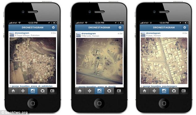
Dronestagram: The service posts images of the locations of drone strikes from Google Maps Satellite view to Instagram along with short summaries of what's there
An influential blogger has launched a new service that posts satellite images of areas hit by U.S. drone strikes as an Instagram feed.
Dronestagram posts images drone strike locations from Google Maps Satellite view to the popular photo-sharing service along with short summaries of what's there
.
The online service is the brainchild of London-based writer James Bridle, who has earned world-wide reknown for his New Aesthetic blog which aims to describe how now-ubiquitous computer networks change how we perceive the world.
He said Dronestagram is his way of 'making these locations just a little bit more visible, a little closer. A little more real.
On his booktwo.org blog, Mr Bridle added: 'Drones are just the latest in a long line of military technologies augmenting the process of death-dealing, but they are among the most efficient, the most distancing, the most invisible.
'These qualities allow them to do what they do unseen, and create the context for secret, unaccountable, endless wars.
'Whether you think these killings are immoral or not, most of them are by any international standard illegal.'
With the UK and U.S. militaries unforthcoming about the activities of their drone fleets, Mr Bridle's Instagram feed - which is syndicated to Tumblr and Twitter - reports records of strikes drawn mainly from the Bureau of Investigative Journalism.
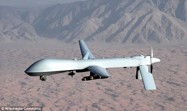
Death from above: A U.S. Predator drone. The U.S. claims that 98 to 99 per cent of its targets are legitimate; critics claim the reverse is true with civilians making up the bulk of drone strike victims
The BIJ compiles reports from Pakistan, Yemen and Somalia and, as well as providing the satellite image, Dronestagram augments these with a variety of sources to offer more background on the targets hit.
The service is similar to the mooted iPhone app Drones Plus, which would have alerted users whenever a person was killed by a U.S. drone strike, but was rejected by Apple.
The Silicon Valley tech giant refused to add the program to its App store three times, with it's latest rejection letter calling the app's content 'objectionable and crude'.
The number of casualties caused by U.S. drone strikes alone has quadrupled under the Obama administration, although the ethics of the highly secretive operations was off the agenda during the recent Presidential election.
The U.S. military claims that between 98 and 99 per cent of those killed by drones are legitimate militant targets, but independent studies claim the overwhelming number of victims are in fact civilians.
The UK military has, if anything, been even cagier about the use of its drone fleet, although Defence Minister Philip Dunne was last week forced to admit that British reaper drones have fired at 349 Afghan targets since 2008.
Mr Bridle points out that means that in that time British forces have launched one drone strike every four days.
For Mr Bridle, using Instagram to highlight the remote areas hit by the drones is just one way in which technology is changing the way we can map the course of history.
'History, like space, is co-produced by us and our technologies: those technologies include satellite mapping, social photo sharing from handheld devices, and fleets of flying death robots,' he said.
'We should engage with them at every level. These are just images of foreign landscapes, still; yet we have got better at immediacy and intimacy online: perhaps we can be better at empathy too.'